Putting Queenstown Bike Trails on a new map
As a crew of keen bikers, Fluid was pretty excited when the Queenstown Mountain Bike Club commissioned us with a special trail map project. Briefed to bring the extensive trails network to life on a new unique, ski piste style illustrated map.
The art of hand-drawn maps
Map design is quite a niche segment of graphic design. There are an infinite number of ways to depict our beautiful landscape, but the ski-piste illustrated maps have a unique aesthetic and beauty. It is a traditional method of painting panoramic terrain maps, that show perspective and are a true and useful guide to a resort.
With mapping technology advancing, sadly, the art of hand-drawn maps is slowly disappearing, so we were stoked QTMBC were keen to create the illustrated map in a traditional hand-painted style.
We ride to get out into the environment and a hand-painted map, with its tactile and organic nature, reflects the outdoors, so what better medium for this job.
The man behind the panoramic painting
Local artist Spike Wademan has called Queenstown home for the last 20 years. Best known for his aviation and marine paintings, he also paints New Zealand’s awesome mountains. With every brush stroke he captures the light and detail of the South Island’s epic alpine landscape. Each tree painted uniquely,
every mountain different, and the details and variations of nature’s beauty carefully captured in every scene.
We knew Spike was the perfect partner to help us illustrate. His stunning base map, beautifully captures Queenstown and its impressive backdrop.
Beauty and accuracy
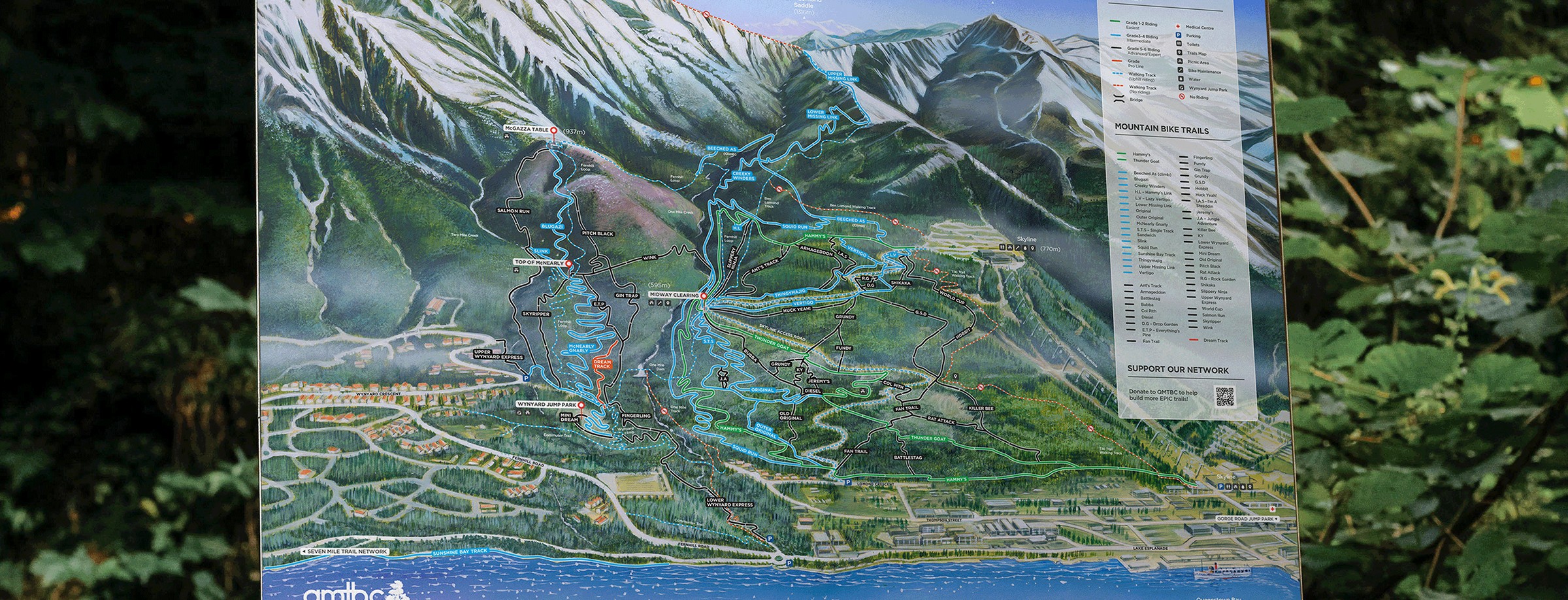
Spike worked to ensure that, to be a useful guide to the area that it interprets Queenstown bike park, Ben Lomond and Fernhill bike park, giving a true feel of the mountain scape. A depiction of a landscape that is as enjoyable and appealing to view as it is practical to use. Accuracy is essential as a tool for a wide variety of end users. The mountain panorama won’t change (unless it experienced a natural event that dramatically altered the topography of the area) so this map becomes a piece of Queenstown history.
Track digital overlay
For years, QTMBC has been the driving force behind the maintenance of popular mountain bike areas in our home. The trails are constantly being advanced and upgraded.
Once the background illustration was complete, we shot high resolution photos of it so we can digitalise it. We then began the process of adding the digital overlays – bike tracks, run names, road names, facility awareness and so on. Digitalising the final piece allows us to update in future without having to edit the original map.
To overlay the tracks we started by talking to the people who know the mountain and the trails best. We asked QTMBC what they like and dislike in their existing maps, and what they want to emphasise or deemphasise moving forward. From there, we gathered information from a visual standpoint, using both aerial and on-the-ground photos and current trail maps to guide placement.
Having ridden a lot of the tracks it gave us a better understanding of how the network links. It’s all information that’s helpful so we can portray the mountain as a trail users might see and navigate it.
The three-dimensional topography of the map meant that the design challenge of overlaying the tracks was complex, requiring an amount of adapting reality into representation.
A piece of history
The Queenstown community is a special one and QTMBC are an incredible representation of how people and their community spirit make this place what it is. We’re privileged and proud to be a part of this piece of Queenstown history.
Soon you’ll be able to own your own version. See if you can spot what lives in Lake Whakatipu?